Laser Scanning: Precise digital capture of plants and buildings

The digital representation of spatial conditions by laser scanning may be necessary for various reasons to record the planning of industrial plants. A 3D laser scan allows the high-precision recording of technical and architectural structures in a data matrix, which can be displayed completely or partially in many forms – for example as 2D graphics, as CAD objects or as high-resolution, detailed virtual reality.
Advantages of a 3D Scan based plant survey
With our 3D plant design, we offer you professional engineering services from the concept planning up to the documentation of the as built status – no matter if it is a new planning or recording of existing plants.
The advantages and possibilities of our 3D scan supported plant design at a glance:
- Fast and exact recording and documentation of buildings, plants and machines as a basis for further planning phases
- Survey of areas that are difficult to access without scaffolding or working platforms by means of a telescopic tripod up to a height of 6m
- High planning reliability due to early detection of collision points and bottlenecks
- Precise pipeline paneling, which enables a high degree of prefabrication and thus significantly reduces installation time
How does laser scanning work?
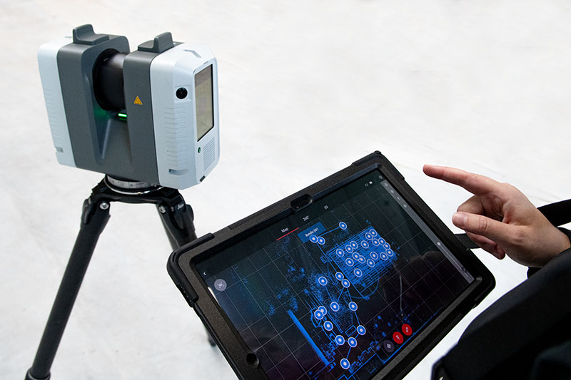
In a 3D laser scan, the scanner emits a laser beam to determine the distance between the device and the scanned object. The laser scanner successively captures a large number of individual measurement points, from which a so-called point cloud is generated. With the help of analysis software, the points are connected to form three-dimensional objects so that the scanned objects can be precisely represented in their spatial positioning and size ratios and virtually processed, for example to optimize the spatial arrangement of highly complex plants.
PCR Engineering - Your partner for high-precision laser scanning
We use Leica RTC360 laser scanners, which enables us to measure your object with high precision and resolution, and a 3-camera system with a resolution of 36 megapixels to digitally capture the colors and textures of the scanned objects. This enables the accurate, detailed rendering later – even across multiple layers and spaces. The use of telescopic tripods eliminates the need for work platforms or scaffolding, reducing effort and costs.
Would you like to learn more about laser scanning or book an appointment for an on-site 3D laser scan?
Do not hesitate to contact our competent team. You can reach us by phone at +49 (0)5407 8177-250 or via contact form. We are looking forward to your request!
3D laser scanning in practice
Using the example of a reactor, you can see here how we proceed when expanding a plant. Our 3D scan-supported plant planning enables precise piping planning in existing plants.
Your advantages
- 3D model as a CAD version of your existing system
- No measuring errors, no forgotten measurements
- Very high accuracy across multiple levels and rooms
- Capture of all geometry and texture
- Short measuring times on site
- Option to include type plates for your documentation in accordance with BetrSichV2015
Technical details
System: Leica RTC360
Speed: 2-5 min per scan point depending on resolution
Accuracy: 1.9 mm per 10 m
Reach: 0.5 to 130 m
For indoor and outdoor use: Housing protection class IP 54 (dust and splash-proof)
Color camera: 3-camera system with 36 megapixels

